Introduction
|
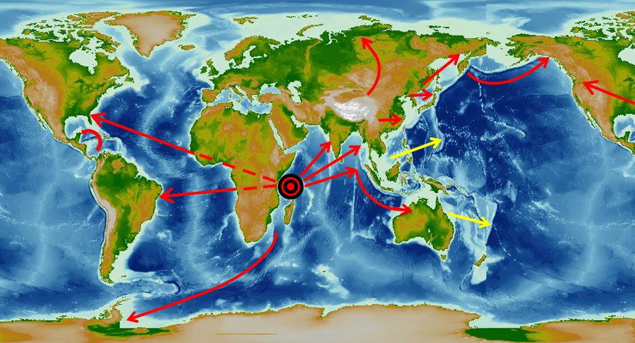
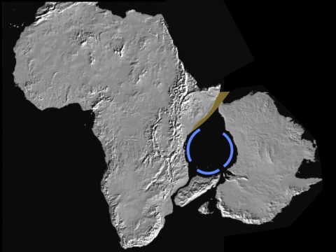
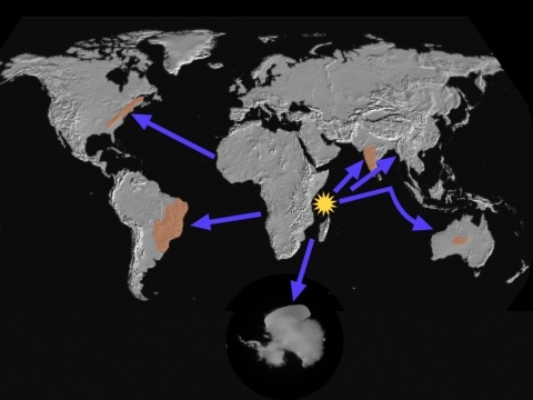
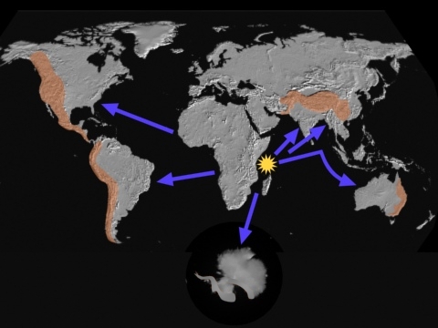
1. All continents that moved (North America, South America, Antarctica, Australia, India, Southeast Asia) went directly away from one unique central point. It is just north of Madagascar in the Western Somali Basin, centered on Wilkes Rise and the Aldabra Islands.
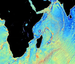
2. At that central point is a feature unlike any other on the ocean floor. It appears to be a giant crater over 600 miles in diameter, based on the distance from the clearly visible central uplift to the edge marked by the Comoros and the Amirante Trench. By comparison, Chicxulub crater is 112 miles in diameter. Click
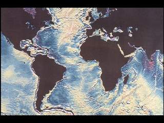
pictures to enlarge
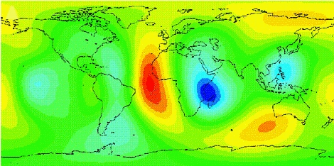
3. The Earth flexes as the Moon revolves around it. The place where it is the least flexible is shown in dark blue below. Something has changed the layers deep below the surface there, and geologists have no idea why. But it is right over the giant crater.
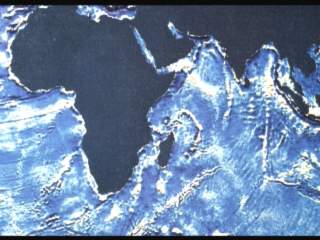
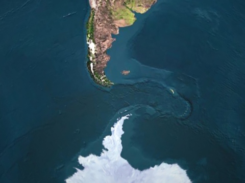
This solid Earth (body) tide projection was "generated from the actual history of the tidal forcing". It is a measure of elasticity. The image was computed using the 3-D model SPRD6 of Ishii and Tromp. --Latychev, Konstantin, Jerry X. Mitrovica, Miaki Ishii, Ngai-Ham Chan, James L. Davis. 2009. Body tides on a 3-D elastic earth: Toward a tidal tomography. Earth and Planetary Science Letters, Vol. 277, No. 1-2, pp. 86-90. "The tidal response of the Earth reveals a great deal about its inner structure." "The calculations show that the perturbation in surface deformation is large, with contributions from both elastic moduli and density heterogeneity." --Ishii, Miaki, Konstantin Latychev, Jerry X. Mitrovica, Ngai-Ham Chan, James L. Davis. Body Tides on a Three-Dimensional Elastic Earth: Toward a Joint Tidal and Seismological Tomography. American Geophysical Union, Fall Meeting 2008, abstract #DI11A-08. 4. In their original positions next to the crater, the coasts of Madagascar, Africa, and Australia are rounded (bights). (The brown segment shows the former position of the Horn of Africa).
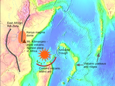
5. Around the crater are features made by powerful forces.
6. Minor mountains on the continents that moved are on the side nearest the crater.
7. Major mountains are on the side farthest from the crater.
8. If continental crust were being carried about on brittle plates, even though it is flexible it would keep its shape. But if continental crust slid on top of a stationary surface, it would stretch and bend, especially where it is narrow.
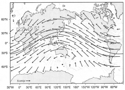
9. The Shock Dynamics event left us with Plate Tectonics Slow Motion If the work attributed to Plate Tectonics over 200 million years was actually accomplished by the Shock Dynamics event in 26 hours, what causes the few centimeters per year of motion of the "plates" measured by GPS? "The fact that plate velocity on Earth does not depend on plate size and that the velocities of the fast plates do not depend on length of the subduction boundary suggests that it is the system, not the individual plate, that dictates plate motions." "The possibility that has been overlooked is that the plates define and organize themselves by mutual interactions of the whole plate system and that minimization of dissipation in the lithosphere may be the organizing rule."1 A number of researchers5,6,7,8 have picked up on the fact that the lithosphere constantly drifts slightly to the west relative to the mantle below it. According to Harvard's Jerry Mitrovica, magnetic coupling between the Earth's iron core and its rocky mantle has been slowing the rotation of the lithosphere.9 "In the hotspot reference frame a 'westward' rotation of the lithosphere can be observed. The origin of this net rotation of the lithosphere is still under debate, but it should range between 4.9 cm/yr and 13.4 cm/yr at its equator."3 In the differential rotation model, the lithosphere and outer core show a net westward drift, while the mantle and inner core move eastwards.5,7 "Because the Antarctic plate is centered on the Earth's south pole and is nearly surrounded by ocean ridges, it can be regarded as an inertial reference with regard to Earth's rotation axis."6 Where the crust is thickest, such as under mountain ranges, there is the most contact with the eastward moving mantle.6 Proponents of differential rotation find that the axis of rotation of the lithosphere relative to the mantle is different than the rotational axis of the whole Earth:
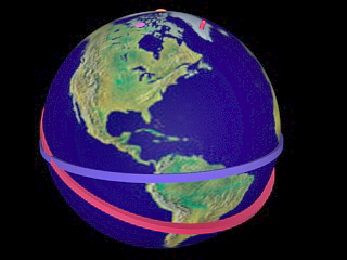
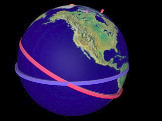
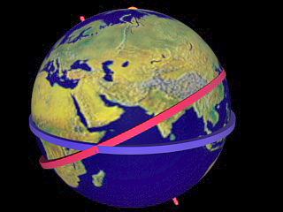
Transferring the rotational path in the above illustration to a globe yields the red ring below. For reference, the blue ring follows the equator. The orange button at the top marks true north; the purple button marks present-day magnetic north; and the red pegs mark the axis of the red ring.
The rotational path above (red band) "has an angle of about 30 degrees with respect to the equator, close to the revolution plane of the Moon about the Earth (28 degrees), although this overlap is intermittent."5 This is significant, because tidal force provides a constant westward pull on the lithosphere.
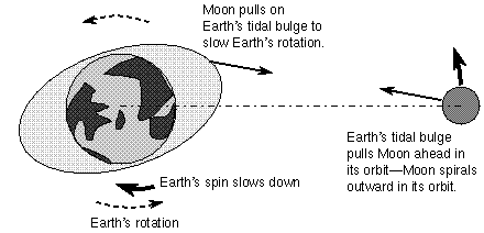
The approximately "2 - 3 degree tidal lag angle between the tidal bulge and the gravitational alignment between the Earth and Moon determines a permanent torque toward the "west", opposite to the eastward rotation of the planet. This torque is considered responsible for the secular deceleration of the Earth, and acts directly on the lithosphere." "To conserve the angular momentum of the system, the Earth's deceleration is mostly compensated by the enlarging of the Moon's orbit, at a rate of 38.2 + 0.7 mm/yr."5
"The solid Earth tides have a well-known vertical oscillation of 300 - 400 mm/12 h 25', but they also have a relevant 150 - 200 mm/12 h 25' horizontal swinging [i.e. stress loading]. Under a permanent torque, this oscillation may induce a tiny strain in the upper asthenosphere, say 0.1 -0.2 mm. The cumulative effect of this small horizontal motion... may well reach several centimeters (7 - 14) per year". "The advantage of this mechanism is to act contemporaneously all over the lithosphere."5
"The idea of tidal drag as the driving mechanism for plate tectonics is particularly intriguing because it is energetically feasible. In fact, the dissipation of energy by tidal friction is slightly larger (1.6 x 10¹⁹ J/yr) than the energy released by tectonic activity (1.3 x 10¹⁹ J/yr)."6 When differential rotation was proposed as a driving mechanism in the early years of Plate Tectonics theory, opponents "discarded Earth's rotation as the cause of the westward drift, claiming that the viscosity necessary to allow decoupling between lithosphere and mantle... is too low when compared with present-day estimates of the asthenosphere viscosity." "Tidal torque provides a sufficiently energetic mechanism to drive this motion, but requires a mechanical decoupling between the lithosphere and the deeper mantle that is incompatible with current understanding of upper-mantle viscosity." However, "the mantle very likely has a nonlinear rheology, and the viscosity of the asthenosphere can be far lower in thin, undetected layers." "A thin, low-viscosity layer (shear zone) could accommodate this motion."6
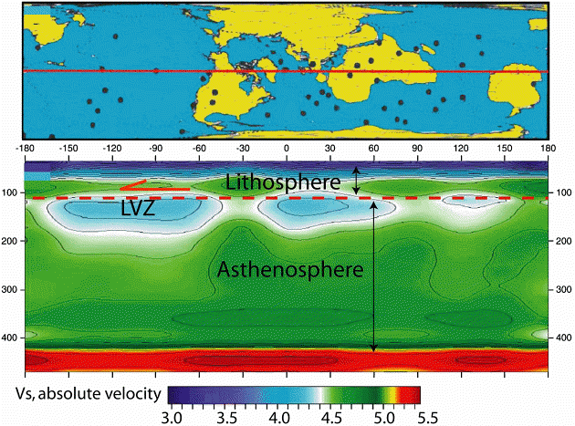
The lower image is a cross-section of the Earth along the red line in the upper image. The black dots in the upper image are stations from which seismic readings were taken. The lower image is called an "absolute shear wave velocity model" that displays the seismic readings. It shows "a pronounced global Low Velocity Zone (LVZ) at the top of the asthenosphere, which is strongest underneath the oceans, but is also clearly identifiable underneath the continents. This level is here inferred as the main decoupling zone at the base of the lithosphere, possibly having an internal sub-layer with ultra-low viscosity, much lower than the average asthenosphere."5 "The viscosity in... the LVZ of the asthenosphere can be much lower than present-day estimates of asthenosphere viscosity based on post-glacial rebound, because horizontal viscosity under shear can be several orders of magnitude lower than the vertical viscosity computed by averaging the whole asthenosphere."5 There is some evidence in two studies of North America to suggest that there is an ultra-low velocity zone at the top of the LVZ, due to shear stress lowering the viscosity of the upper asthenosphere, using the standard assumption of non-linear rheology of the mantle.5 In fact, tests on olivine crystals by a French and German team of scientists2 found "that previously published high-temperature flow laws (i.e., power flow law) overestimate the strength of lithospheric mantle, since all samples deformed under stresses that were significantly lower than those predicted by these flow laws." Their research was aimed at understanding "the plasticity of the uppermost part of Earth's mantle, just below the Mohorovicic discontinuity (Moho), which separates the crust and the mantle". At "pressures and temperatures relevant to the uppermost mantle in continental and oceanic plates (pressures below 3 gigapascals and temperatures in the range of 500 to 1000 degrees Centigrade)", their findings indicate "a weak strength of Earth's uppermost mantle lithosphere".2 In the Shock Dynamics view, the "frozen" edges of crustal waves in the Pacific and beneath the leading edges of continents that moved became what Plate Tectonics calls plate boundaries. They are zones of weakness in the lithosphere, subject to shear, compression or extension. These angled faults solve the problem of subduction initiation that plagues Plate Tectonics. Known as Benioff zones, they vary in depth up to 300 km, and apparently engage the upper mantle in its relative eastward motion, as do other deep sections of the lithosphere. Thus the tiny measured motions of the "plates" is the interaction of the lithosphere with the mantle as the lithosphere drifts westward due to tidal forces. The boundaries of the "plates" (spreading ridges and subduction zones) formed during the Shock Dynamics event, except for the East Pacific Rise which formed much earlier following Earth's grazing collision with a planetesimal that produced the protocontinent. That "subduction zones" are as described in presentation 10 and not sinking slabs is evident from the fact that "large, intermediate-depth (60-300 km) earthquakes have subhorizontal rupture planes."4 That is, earthquake faults at these depths are close to horizontal rather than at the angle of the supposedly diving slab. Once the sliding landmasses slowed sufficiently, the lubricating mechanism beneath them was lost and the continents became firmly attached to the lithosphere. Plates Oceanic lithosphere is roughly 100 km thick. Plate Tectonics theory is based on the notion that the lithosphere is formed at mid-ocean ridges and dives into the earth at trenches. This is not the case in the Shock Dynamics theory, which says that the divisions in the lithosphere are features that formed at the surface and extend deep into the lithosphere, enhanced by "slow motion" differential rotation (see below). There
are substantial areas on the Earth that are not part of the 14 large
"plates" of Plate Tectonics theory that one hears so much
about. A study has found 38 additional "small plates"
plus a number of zones designated as "orogens" with fuzzy
plate boundaries. The largest "orogen"
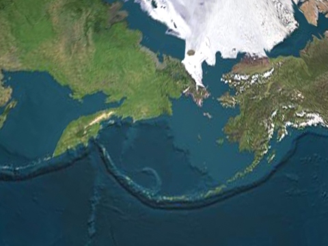
stretches from Korea to the Alps. Another covers Alaska and
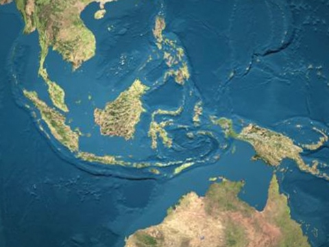
its connection with Canada. Most of the small plates (or microplates)
are in the region where the Australia-Southeast Asia block shattered
against Asia and scattered to the east. These exceptions to
the rule require special interpretation in Plate Tectonics theory,
and bring to mind the attempts to salvage the Earth-centered view
of the solar system by adding "epicycles" to the orbits
of planets in the days before Galileo. "In the classical view, the motion of a plate was driven
from within by body forces". "However, a common
hypothesis is that microplates are externally driven, i.e., that
larger neighbor plates determine their motion." A study
of the Baja California microplate indicates that it is loosely coupled
to North America, and that 90% of its motion is from being dragged
by the Pacific plate. In the Shock Dynamics view, this kind of jostling is what is occurring today all over the globe on every "plate" in slow motion. "Large plates move coherently, being decoupled at the Low Velocity Zone (LVZ). They show that the force acting on them is uniformly distributed and not concentrated on their margins."5 In fact, the principal driving force of Plate Tectonics theory, slab pull on a plate margin, "would be stronger than the strength plates can sustain under extension (pull)."5 **************** 1. Anderson, Don L. 2002. Plate Tectonics as a Far- From- Equilibrium Self-Organized System. in Plate Boundary Zones, Geodynamics Series 30, American Geophysical Union, pp. 411-425. 2. Demouchy, Sylvie, Andrea Tommasi, Tiziana Boffa Ballaran, Patrick Cordier. 2013. Low strength of Earth's uppermost mantle inferred from tri-axial deformation experiments on dry olivine crystals. Physics of the Earth and Planetary Interiors, Vol. 220, pp. 37-49. 3. Doglioni, Carlo, Eugenio Carminati, Marco Cuffaro, Davide Scrocca. 2007. Subduction kinematics and dynamic constraints. Earth-Science Reviews, Vol. 83, pp. 125-175. 4. Kiser, E., M. Ishii, C.H. Langmuir, P.M. Shearer, H. Hirose. 2011. Insights into the mechanism of intermediate-depth earthquakes from source properties as imaged by back projection of multiple seismic phases. Journal of Geophysical Research, Vol. 116, B06310, pp. 1-26. 5. Riguzzi, Federica, Giuliano Panza, Peter Varga, Carlo Doglioni. 2010. Can Earth's rotation and tidal despinning drive plate tectonics? Tectonophysics, Vol. 484, pp. 60-73. 6. Scoppola, B., D. Boccaletti, M. Bevis, E. Carminati, C. Doglioni. January/February 2006. The westward drift of the lithosphere: A rotational drag? GSA Bulletin, Vol. 118, No. 1/2, pp. 199-209. 7. Smith, Alan D., Charles Lewis. 1999. Differential rotation of lithosphere and mantle and the driving forces of plate tectonics. Geodynamics, Vol. 28, pp. 97-116. 8. Smith, Alan D., Charles Lewis. 1999. The planet beyond the plume hypothesis. Earth-Science Reviews, Vol. 48, pp. 135-182. 9. Shaw, Jonathan. September-October 2016. The Plastic Earth. Harvard Magazine, Vol. 119, No. 1, pp. 46-49. http://harvardmagazine.com/2016/09/the-plastic-earth |
|
|