 |
Continents sliding away from a central explosion does appear to produce the shapes and features of most of Earth's crust in a simple, straightforward way. Once it is clear that an event happened, the discussion about whether it is possible or not is over, and the question turns to "how?". How did the landmasses slide?
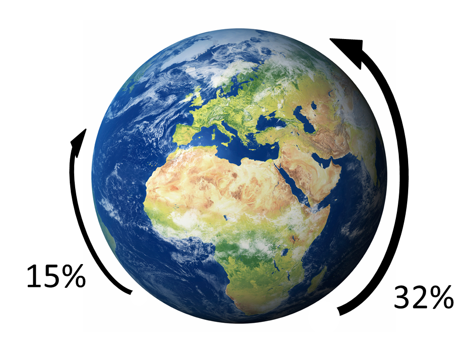
For perspective, note that while several thousand miles is a long way for us humans, most of the continents slid only 12-16% of the distance around the world at the equator. Australia went farthest: 32% of Earth's circumference.
People are too small to experiment with huge continents, so any explanation must be speculation. However, there is an interesting possibility.
An odd phenomenon has been identified on Earth and other members of the solar system. Large landslides don't just fall to the base of the mountain the way small ones do; they often go great distances, some up to 30 times the distance they fell.

Dr. H. J. Melosh has proposed that long-runnout
landslides, earthquake slip, and the making of complex craters reveal a characteristic
of the crust. Put simply, it temporarily acts like a fluid when
enough stress is applied. In 1979 he gave it the name "acoustic fluidization."
Melosh, H. Jay. Dec 10, 1979. Acoustic
Fluidization: A New Geologic Process? Journal of
Geophysical Research, Vol. 84, No. B13, pp. 7513-7520.
Well
known on a small scale as a Bingham Fluid, Melosh suggests that
fluidization at the base of large landslides reduces friction
to near zero.
Collins, Gareth
S., H. Jay Melosh. 2003. Acoustic
Fluidization and the Extaordinary Mobility of Sturzstroms. Journal of Geophysical Research,
Vol. 108, No. B10, 2473 EPM 4, pp. 1-14.
Melosh, H.J. 1989. Impact
Cratering: A Geologic Process. Oxford University
Press, New York.
Corresponding to the falling side of a mountain that powers a landslide, the explosive power released by the giant meteorite on impact would have set the landmasses in motion with the force of billions of megatons of TNT, generating acoustic energy. The continental crust's mass would confine the acoustic energy to the base of the crust.
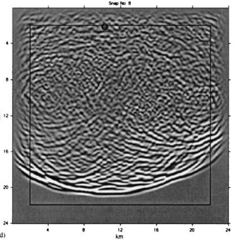
These are snapshots from models
of wave field propagation in the crust. Note the disturbance
in the entire region behind the wave front: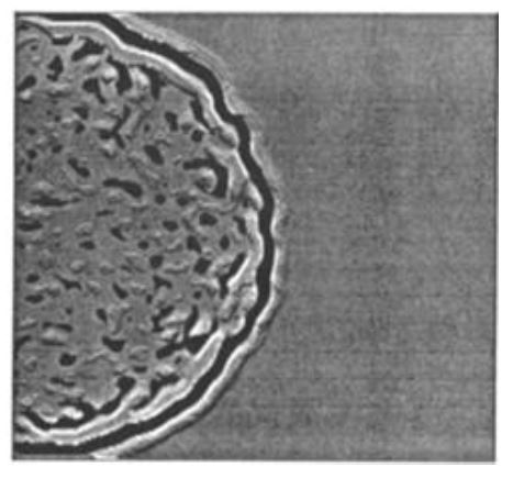
Left - Frankel, Arthur,
Robert W. Clayton. May 10 1986. Finite Difference Simulations of
Seismic Scattering: Implications for the Propagation of Short-Period
Seismic Waves in the Crust and Models of Crustal Heterogeneity.
Journal of Geophysical Research, Vol. 91, No. B6, pp. 6465-6489.
Right - Martini, Francesca, Christopher J. Bean, Sean Dolan, David Marsan. 2001. Seismic image quality beneath strongly scattering structures and implications for lower crustal imaging: numerical simulations. Geophysical Journal International, Vol. 145, pp. 423-435.
Nowadays, "the
weakening mechanism most widely adopted in numerical impact simulations
is acoustic fluidization." "According to this idea,
pressure fluctuations in the fragmented rock mass behind the impact-generated
shock wave periodically allow sliding to occur at lower shear stresses
than would occur under the normal overburden pressure. The
space- and time-averaged result of this process provides a temporary
'fluidization' of this material for as long as strong pressure fluctuations
persist. Acoustic fluidization is the most widely adopted
explanation because numerical models that employ it as a weakening
mechanism have successfully reproduced many specific craters and
the general crater sizemorphology progression." "In
the Block-Model of acoustic fluidization, some fraction of strong,
transient pressure fluctuations (seismic energy) initiated by the
passage of the impact-generated shock wave is responsible for temporarily
counteracting overburden pressure, thereby reducing the frictional
resistance of the blocks within granular breccia."
Silber,
Elizabeth A., Gordon R. Osinski, Brandon C. Johnson, Richard A.
F. Grieve. 2017. Effect of impact velocity and acoustic fluidization
on the simple-to-complex transition of lunar craters. Journal of
Geophysical Research: Planets, Vol. 122, doi:10.1002/2016JE005236.
In a paper computer-modelling long-runnout landslides, Melosh and two others wrote: "For rock masses with volumes exceeding 109 m3, these landslides regularly run out more than 10 times longer than the height they fall from."
"Many mechanisms have been proposed to explain this apparent reduction of friction: riding atop a cushion of trapped air; lubrication by water; a basal frictional melt layer; frictionally warmed ice; frictional velocity-weakening; a basal layer of colliding grains (dispersive grain flow); and acoustic fluidization."
"Our results are very similar to the predictions of the acoustic fluidization hypothesis, where the flow is effectively fluidized by local variations in the contact forces between the grains. Acoustic fluidization is similar to the pore pressure fluctuations observed in debris flows, but without an interstitial fluid. The acoustic fluidization wavelength is determined by the size of the rock fragments in the slide."
"Friction is reduced even during the earliest stages of the slide. Although the slides have similar maximum velocities, larger slides initially accelerate faster than the smaller slides, implying a smaller effective coefficient of friction even at the onset of sliding."
"We note that channelized slides do not exhibit
systematically longer runout distances than unconfined slides, suggesting that
spreading perpendicular to the main slide path is not of fundamental importance
to the runout."
Johnson, Brandon C., Charles S. Campbell, H. Jay Melosh.
2016. The reduction of friction in long runout landslides as an emergent
phenomenon. Accepted for publication, in press, Journal of Geophysical
Research.
Most fault systems exhibit a resistance to shear stress
much smaller than the one predicted by experiments measuring the friction
coefficient of sliding rocks. A possible
explanation of this unexpected observation is represented by 'acoustic
fluidization' (AF).
Giacco, F., L. Saggese,
L. de Arcangelis, E. Lippiello, M. Pica Ciamarra. 15 September 2015. Dynamic
Weakening by Acoustic Fluidization during Stick-Slip Motion. Physical Review
Letters, Vol. 115, No. 12, pp. 128001-1 to 5. DOI:10.1103/PhysRevLett.115.128001
Steady slip is possible under conditions of constant applied shear stress because strong vibrations in the fault core permit the material there to flow like a viscous liquid.
[A]n important question is how does the process get
started. [S]ome kind of trigger event,
perhaps a high stress-drop event in a limited area of the fault, must generate
enough vibration over a large enough volume to permit the acoustic energy field
to sustain itself and grow.
Melosh, H.J. 15 February
1996. Dynamical weakening of faults by acoustic fluidization. Nature, Vol. 379,
No. 6566, pp. 601-606. DOI:10.1038/379601a0
According to the AF mechanism, a seismic fracture produces elastic waves that diffuse and scatter inside the fault, generate a normal stress contrasting the confining one, and thus promote seismic failure. The same mechanism could be also activated by transient seismic waves generated by other earthquakes.
[O]ur results strongly support the validity of the AF
scenario by proving that the system is susceptible to external perturbations
with a characteristic frequency. [T]hese
oscillations are able to cause a slip instability regardless of their origin.
This is important because it means seismic waves generated
by the giant impact could start AF.
Giacco, F., L. Saggese,
L. de Arcangelis, E. Lippiello, M. Pica Ciamarra. 15 September 2015. Dynamic
Weakening by Acoustic Fluidization during Stick-Slip Motion. Physical Review
Letters, Vol. 115, No. 12, pp. 128001-1 to 5. DOI:10.1103/PhysRevLett.115.128001
There is an important
feature of long-runnout landslides that have stopped moving:
"Ridges formed at the front and rear of the debris support
the hypothesis that the leading edges of the slide initially ground
to a halt and the rest of the material piled up behind it."
Campbell,
Charles S. 1989. Self-lubrication for long runnout landslides. The
Journal of Geology, Vol. 97, No. 6, pp. 653-665.
"Structural observations from the peak-ring target rocks of
Chicxulub [crater] are generally consistent with acoustic fluidization as the dominant
weakening mechanism. Drilling of the
approximately 200-km diameter Chicxulub impact structure in Mexico has produced
a record of brittle and viscous deformation within its peak-ring rocks. The observations point to quasi-continuous
rock flow and hence acoustic fluidization as the dominant physical process
controlling initial cratering."
Riller, Ulrich et al. 25 October 2018. Rock fluidization
during peak-ring formation of large impact structures. Nature, Vol. 562, pp.
511-521.
|
|
|
The largest impact craters have central basins with numerous concentric rings hundreds of kilometers from the center of the crater. For these "multi-ring basins", "the radial spacings on the Moon, Mercury, and Mars are statistically not random. They exhibit a rule of internal spacing." "The ring-forming hypotheses of multi-ring basins may be divided into three groups: structure, target strength, and wave form. The former two models cannot explain the spacing rule mentioned above, while the wave form model can." "The basic idea of this model[, the tsunami model,] is that a basin-size impact would release energy and fluidize the solid matter within the region where the peak shock pressure is larger than the rock-failure pressure, so that the tsunami-like waves generated after impact can move through this fluid region. Beyond this the rocks cannot move in the form of fluid, the tsunami action stops and the fluid exhibits a 'frozen' state." "As an approximation of first order, to regard the gross behavior of the target material as water is reasonable. Thus the mechanism of ring formation is simplified to water waves propagating from an initial pressure or deformation disturbance." |
Shi Jian-chun, Ma Yue-hua, Bao Gang. 2009. The Formation Model of Multi-ring Basins Based on the Theory of Impact Tsunami. Chinese Astronomy and Astrophysics, Vol. 33, pp. 287-292.
"The acoustic wave field may evolve by progressive
lengthening of the dominant vibrational wavelength during cratering as
higher-frequency vibrations dissipate sooner." So the wavelength would increase greatly as it moved out
from the crater.
Riller, Ulrich et al. 25 October 2018. Rock fluidization
during peak-ring formation of large impact structures. Nature, Vol. 562, pp.
511-521.
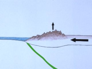
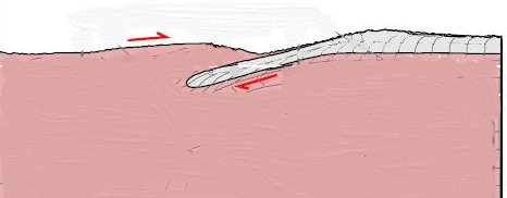
The Shock Dynamics scenario

In
this side view (not to scale), continental crust (brown) is on
basaltic crust and lithosphere (ochre) above the mantle (red).
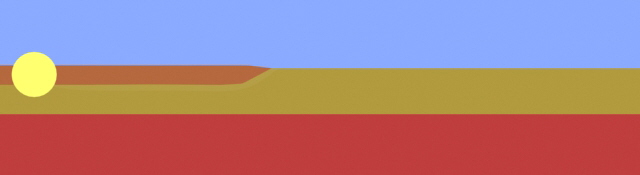
The
giant meteorite explodes deep inside the continental crust.
The
force pushes up low mountains, and the landmass slides away like
a ship
on water, fluidizing the contact layer. Behind the
landmass, a surface layer of
oceanic crust is melting and cooling
to form the mid-ocean spreading ridge
with transform faults,
pulled open by the landmass.
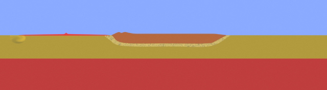
When
the leading edge loses enough energy, the contact layer at the leading
edge
solidifies. The momentum of the landmass carries it
forward like a car hitting a wall,
piling up high mountains.
The formerly fluidized contact layer in front (gray line)
is a
Benioff zone, called subduction zones in Plate Tectonics.
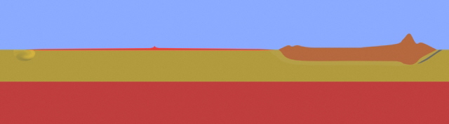
With all the action at the surface, it follows that features in the oceanic crust are fairly shallow. They include these:
Mid-ocean ridges and transform faults, where surface melting results from the removal of the weight of continental crust (pressure relief melting).
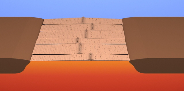
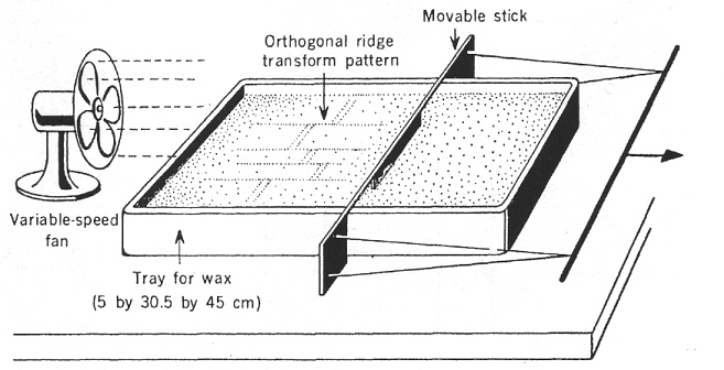
Oldenburg, Douglas W., James N. Brune. 20 October 1972. Ridge Transform Fault Spreading Pattern in Freezing Wax. Science, Vol. 178, No. 4058, pp. 301-304.
Another experiment with spreading wax plates found that fast rates of separation produced longer transform faults and larger distances between ridge segments.
Ragnarsson, Rolf, J. Lewis Ford, Christian D. Santangelo, Eberhard Bodenschatz. 29 April 1996. Rifts in Spreading Wax Layers. Physical Review Letters, Vol. 76, No. 18, pp. 3456-3459.
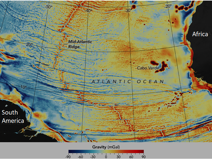
From:
https://earthobservatory.nasa.gov/images/87189/seafloor-features-are-revealed-by-the-gravity-field
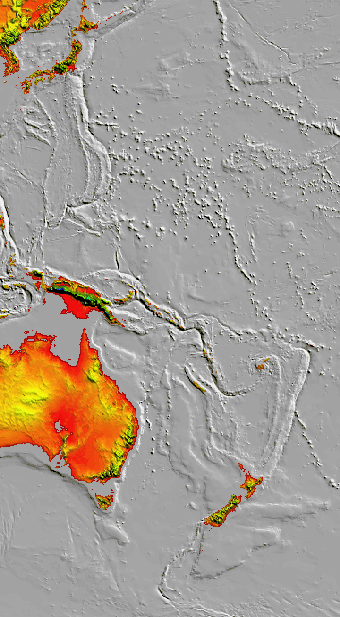
Subduction zones (green line) along the leading edges of landmasses result from the rapid application of the weight of continental crust. Towards the end of a continent's run, friction compresses the leading edge, raising mountains.
A crustal wave (red line) from the low angle impact was launched in the direction of travel of the meteorite, and "froze" in the end to form an inclined subduction zone.
|
|
|
|

Adapted
from: Riller, Ulrich et al. 25 October 2018. Rock fluidization
during
peak-ring formation of large impact structures. Nature, Vol. 562, pp.
511-521.
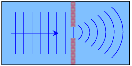
Wave
diffraction
|
The Izu-Bonin-Mariana Trench portion of the crustal wave diffracted (bulged) as it passed through the shattered Southeast Asia block. But it still shows the same ridge structure as the Tonga-Kermadec Trench. |
|
The Tonga-Kermadec Trench portion of the crustal wave advanced unimpeded, except at its northern tip. It froze with a wide ridge behind the contact edge and a thin ridge farther back.
|
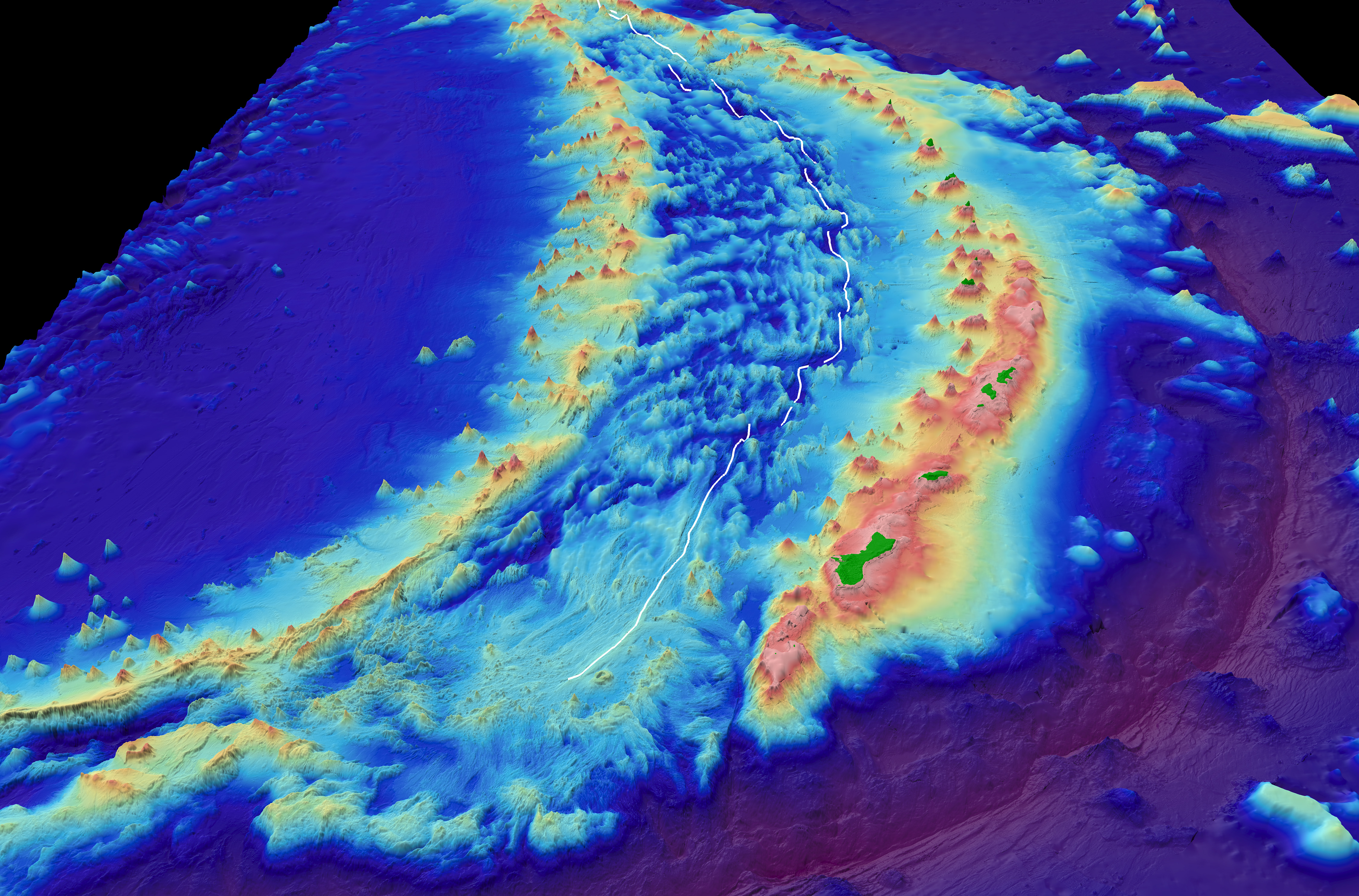
Below is a detailed computer-generated 3D map of the Mariana Trench terrain at the bow. The colors designate elevation. Notice the wavy light-blue seafloor ridges that look like clouds between the arcs. They tell us these features were formed by fluid turbulence.
![]()