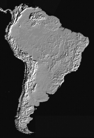
Mountains
|
|
"Close examination of a globe often results in the observation that most of the continents seem to fit together like a puzzle: the West African coastline seems to snuggle nicely into the east coast of South America". "In 1912 Alfred Wegener (1880-1930) noticed the same thing and proposed that the continents were once compressed into a single protocontinent which he called Pangaea (meaning "all lands"), and over time they have drifted apart into their current distribution." "Wegener's drift hypothesis also provided an alternate explanation for the formation of mountains (orogenesis)." |

Wegener's explanation was that as the continents moved, the leading edge of the continent would encounter resistance and thus compress and fold upwards forming mountains near the leading edges of the drifting continents. The Sierra Nevada Mountains on the Pacific coast of North America and the Andes on the coast of South America were cited. Wegener also suggested that India drifted northward into the Asian continent thus forming the Himalayas. - UCMP Berkeley
"Virtually
all major mountain ranges in the world are a consequence of crustal
shortening."
Some
Simple Physical Aspects of the Support, Structure, and Evolution
of Mountain Belts. Peter Molnar, H. Lyon-Caen. Special Paper
218, Geological Society of America, 1988, pp. 179-207.
"Our
compilation of mountains throughout the world shows that a major
phase of uplift occurred in the Pliocene-Pleistocene." "Uplift
occurred over a relatively short and distinct time. Some earth
process switched on and created mountains after a period with little
or no significant uplift. This is a deviation from uniformitarianism."
The
Origin of Mountains. Cliff Ollier, Colin Pain. 2000. Routledge,
London. p. 303.
The presence of mountains on the front and back sides of continents (along their line of travel), the relatively short distances travelled, and the brief burst of mountain building point to a sudden impulse rather than a steady, constant force moving the continents. Important driving forces of plate tectonics theory are too weak to raise mountains.
In Shock Dynamics, the shock wave from the giant meteorite impact provided the impulse that initiated continental motion. Some continents began moving after being hit by a continent already set in motion by the impact. Assuming the acoustic fluidization mechanism, and assuming that mountains are built through lateral compression, the minor mountains (such as the Appalachian Mountains) raised by the impulse against a continent's back side indicate a comparatively slow acceleration. The major mountains (such as the Rocky Mountains) raised on the front, or leading, side indicate a sudden deceleration, like a multi-car pile-up on a highway. This braking effect all along the leading edge suggests that acoustic energy was lost most rapidly there, probably through thinning the overlying mass confining the acoustic energy. Most other mountains were laterally compressed by means of collision with other continents or by torque.
North and South America stopped suddenly because their western sides grabbed the lithosphere below them. These huge landmasses transferred their momentum to the lithosphere, Earth's outer shell.
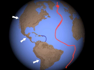
So with a jolt, Earth's outer shell, the lithosphere, suddenly slowed its eastward rotation relative to the shell below it, the upper mantle. We can see this displacement by comparing two scars in the Earth from the giant impact; one shallow, one deep.
In the Shock Dynamics interpretation, they were both made by the same meteorite impact, but the depression in the upper mantle (above right) rotated past the focus of inelastic lithosphere (above left). Notice that this "differential rotation" of the lithosphere versus the upper mantle was not directly east to west but westsouthwest.
Proponents of differential
rotation find
that the axis of rotation of the lithosphere relative to the mantle today
is different than the rotational axis of the whole Earth. In
this model, the lithosphere and outer
core show a net westward drift, while the mantle and inner core
move eastward.
Riguzzi, Federica,
Giuliano Panza, Peter Varga, Carlo Doglioni. 2010. Can Earth's rotation
and tidal despinning drive plate tectonics? Tectonophysics, Vol.
484, pp. 60-73.
Smith, Alan D., Charles Lewis. 1999. Differential
rotation of lithosphere and mantle and the driving forces of plate
tectonics. Geodynamics, Vol. 28, pp. 97-116.
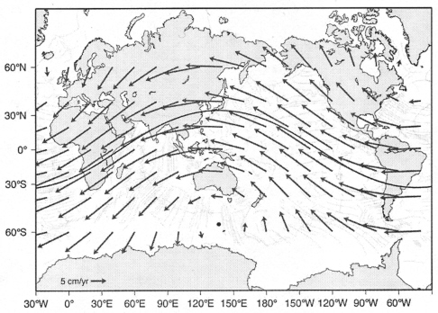
Global
lithospheric net rotation relative to the mantle assuming a
mid-asthenospheric source of the Pacific plumes.3
Transferring the rotational path in the above illustration to a globe yields the red ring below. For reference, the blue ring follows the equator. The orange button at the top marks true north; the purple button marks present-day magnetic north; and the red pegs mark the axis of the red ring.
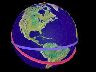
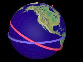
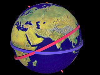
The rotational path above (red band) "has an angle of about 30 degrees with respect to the equator, close to the revolution plane of the Moon about the Earth (28 degrees), although this overlap is intermittent."5
So the two scars from the Shock Dynamics giant impact separated on a path parallel to the red band above, the direction of lithosphere/upper mantle differential rotation.
Differential rotation
continued thereafter and still does, but at a creeping pace of 5
to 13 cm per year.
Doglioni, Carlo, Eugenio Carminati, Marco Cuffaro,
Davide Scrocca. 2007. Subduction kinematics and dynamic constraints.
Earth-Science Reviews, Vol. 83, pp. 125-175.
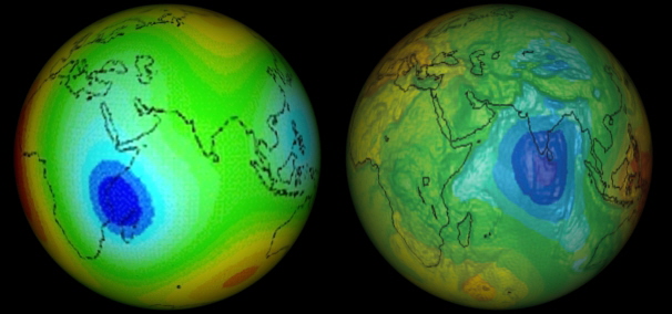
Both blue features on the two world maps below are unique on the Earth.
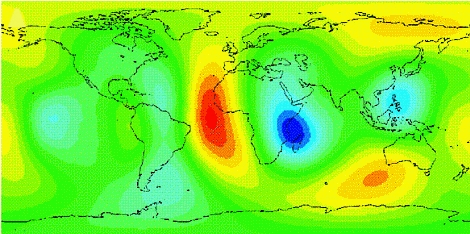
The Earth flexes as the
Moon revolves around it. The place where it is the least flexible
is shown in dark blue above, next to Africa. This solid Earth (body) tide
projection was "generated from the actual history of the tidal
forcing". It is a measure of elasticity.
Latychev, Konstantin, Jerry X. Mitrovica,
Miaki Ishii, Ngai-Ham Chan, James L. Davis. 2009. Body tides on
a 3-D elastic earth: Toward a tidal tomography. Earth and
Planetary Science Letters, Vol. 277, No. 1-2, pp. 86-90.
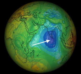
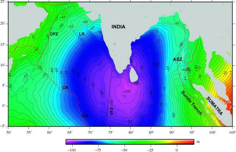
And the only deep geoid/gravity anomaly low on Earth is shown in dark blue below, next to India:
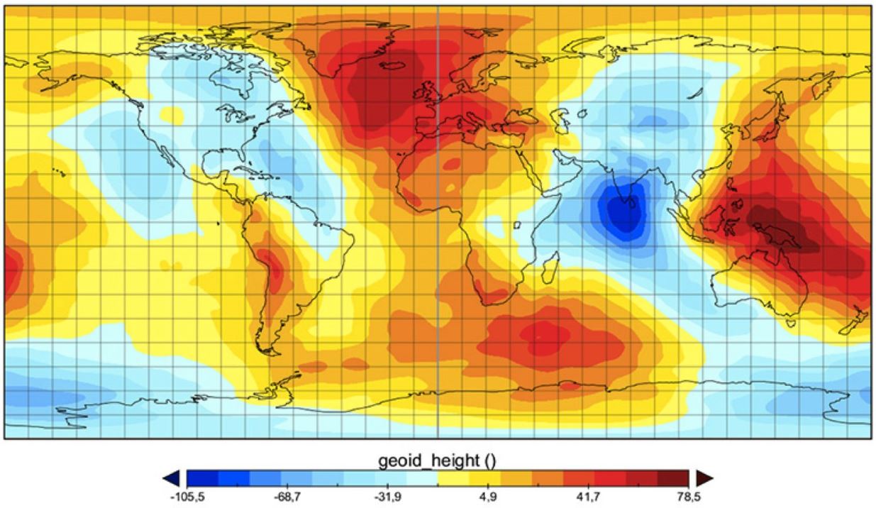
From: The Gravity Field and Steady-State Ocean Circulation
Explorer (Goce) global geoid map, 2010,
European Space Agency
From: Sreejith, K.M., S. Rajesh, T.J. Majumdar, G. Srinivasa
Rao, M. Radhakrishna, K.S. Krishna, A.S. Rajawat.
30 January 2013.
High-resolution residual geoid and gravity anomaly data of the northern Indian
Ocean
- An input to geological understanding. Journal of Asian Earth Sciences,
Vol. 62, pp. 616-626 https://doi.org/10.1016/j.jseaes.2012.11.010
"The existence of the Indian Ocean Geoid Low (IOGL) is one of the most outstanding problems in Earth Sciences," said Attreyee Ghosh, an assistant professor at the Centre for Earth Sciences, Indian Institute of Science, in Bangalore, India. "It is the lowest geoid/gravity anomaly on Earth and so far no consensus exists regarding its source. It is remarkable as it means that there is some mass deficit in the deep mantle that's causing the low."
"To 'look' deep inside the Earth, they used seismic tomography models that use seismic waves to obtain a 3-dimensional picture of the Earth's interior. The study showed that lighter material (low density anomalies) in the upper to mid mantle below the IOGL seem to be responsible for the existence of the gravity low in this region."
" 'Our study explains this low with hotter, lighter material stretching from a depth of 300 km, or 186 miles, up to ~900 km, or 559 miles, in the northern Indian Ocean' ".
See interview at: https://phys.org/news/2017-10-masswhat-geoid-indian-ocean.html
Two cross-sections (A - A' and C - C') of the IOGL are shown below the transect map. They derive from the GyPSuM_S seismic tomography model. Notice that the hot material is not the top of a plume, and is isolated below the lithosphere between about 300 km and 500 km depth. That is what we would expect if the lithosphere moved westsouthwest, as described above, bringing new lithosphere over the upper mantle that took the hit from the giant meteorite. The surface and upper mantle impact scars are now separated.
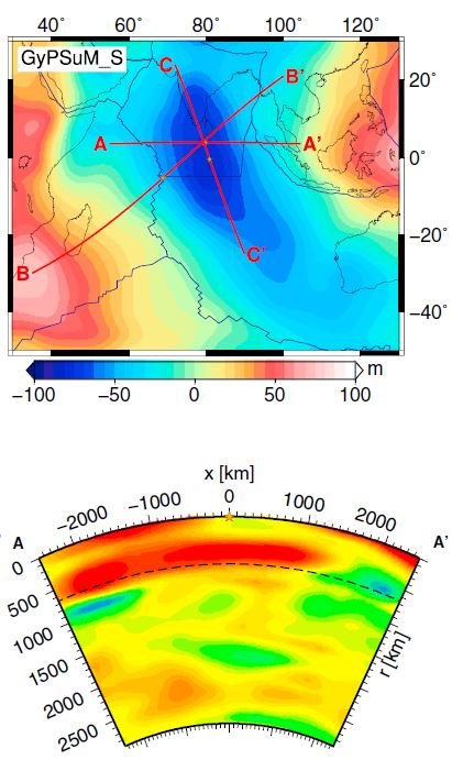
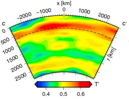
From: Ghosh, Attreyee, G. Thyagarajulu, Bernhard Steinberger. 2017. The Importance of Upper Mantle Heterogeneity in Generating the Indian Ocean Geoid Low. Geophysical Research Letters, Vol. 44, pp. 9707-9715 DOI:10.1002/2017GL075392
![]()