Shock effects |
On the east side of the impact, the big slabs of continental crust (India, Australia, Southeast Asia, Antarctica) were hurled away. What happened on the west side, where there was a lot more land?
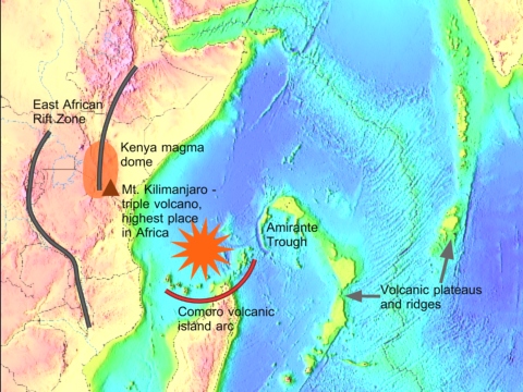
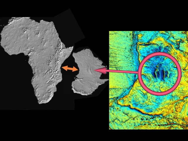
The east coast of Africa buckled, forming the longest rift system in the world. The worst damage was closest to the impact, which also pushed magma up into the crust.
Shock energy passed through Africa and sent the Americas sliding
as in this example of spallation
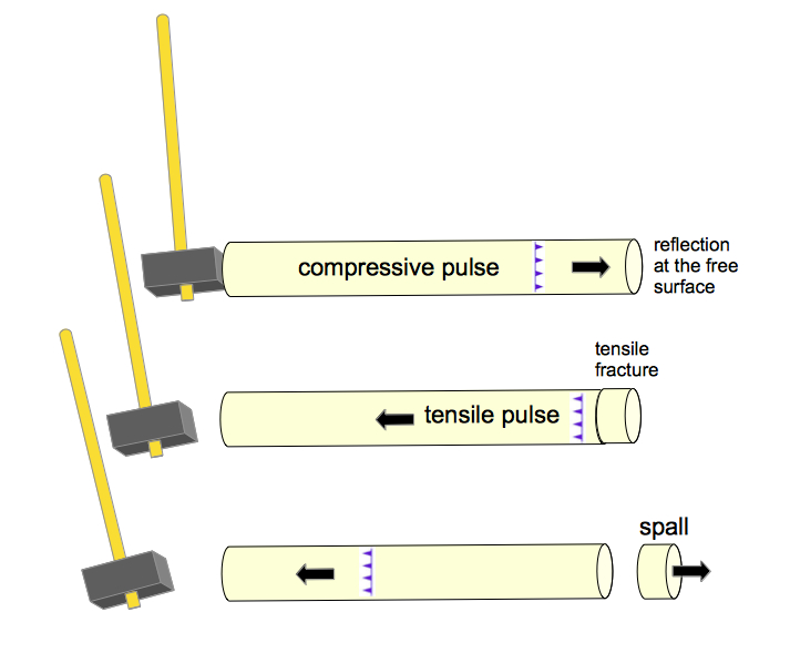
and these croquet balls transferring energy from a mallet blow.


The same thing happened to Madagascar and the Seychelles, which is why Africa, Madagascar, and the Seychelles stayed pretty much where they started.
The blast left similar scars on Australia and East Africa, though Australia's was less intense because it was able to move away.
Color image from "Gravity anomaly map of the Australian region", Australian Geological Survey Organization
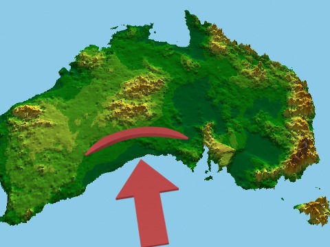
Central
Australia was compressed more than 180 km. This major crustal
shortening is known as the Petermann and Alice Springs Orogenies.
Hand,
Martin, Mike Sandiford. 1999. Intraplate deformation in central
Australia, the link between subsidence and fault reactivation.
Tectonophysics, Vol. 305, pp. 121-140.
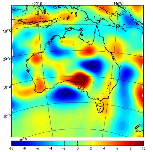
Note the red zone in south-central Australia in the magnetic anomaly map above. A study found that "enhanced crustal magnetization is consistent with the effects of giant meteorite impact that pervasively disrupted the crust and upper mantle of... south-central Australia." Significant "crustal igneous, metamorphic, and structural alterations also extended into south-central Australia. The thermal effects of the impact enhanced lower crustal VRM [viscous remanent magnetization] and spawned the production of igneous rocks in the fractured crust that further enhanced regional crustal magnetization." von Frese, R.R.B., H.R. Kim, T.E. Leftwich, J.W. Kim, A.V. Golynsky. 2013. Satellite magnetic anomalies of the Antarctic Wilkes Land impact basin inferred from regional gravity and terrain data. Tectonophysics, Vol. 585, pp. 185-195.
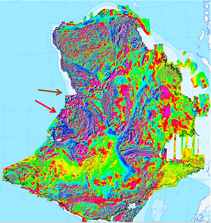
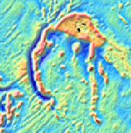
In the detailed magnetic anomaly map below you can see how the giant impact blast crushed the Great Australian Bight in the direction of the red arrow. The crushed zone measures 620 miles from end to end (magenta is the highest intensity). The brown arrow points towards the Petermann and Alice Springs Orogenies, corresponding to the Amirante Trough on the eastern side of the West Somali Basin.
Milligan,
P.R., R. Franklin, B.R.S. Minty, L.M. Richardson, P.J. Percival.
2010.
Magnetic Anomaly Map of Australia (Fifth Edition), Geoscience
Australia, Canberra
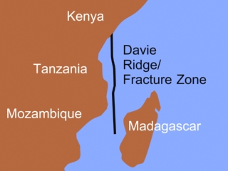
Amirante
Arc/Ridge and Trough/Trench
See top of page for location
The perplexing Amirante Arc/Ridge and Trough/Trench feature sits by itself in the Western Indian Ocean, far from other trenches, surrounded by spreading zones. The trough/trench is about 550 km (342 mi) long, and at its deepest is nearly a mile below the surrounding basin floor. The center is fairly straight, while the ends curve away from Africa. The ridge lies along the east side of the trough/trench.
This feature has been seen by various researchers as a single distinct unit2,4, as a pair of segments3, as three linear segments1, and as a series of curved segments5. Some have thought that part3,4 or all2 of the feature was formed by limited or brief subduction, although the trench does not extend below the crust, the ridge contains no island-arc-type volcanic rocks, and the trench is free of earthquakes. Others see no evidence of compression in part or all of the feature, and suggest it was formed instead from transform faults3,1, fracture zones and tensional rifting1, or wrenching from plate rotation5. That uses up pretty much all of the options available in Plate Tectonics. Little more has been added to the subject in professional journals since 1996.
Looking at it from the perspective of Shock Dynamics, one sees that the long central portion of the trough directly faces the center of the crater, Wilkes Rise. It sits on the edge of the crater where the Australian Bight was carved out by the impact explosion. High compression there is because all of Southeast Asia sits behind Australia and so has greater inertia. The ends of the trough/trench curve away from the crater, pulled by the continental crust rushing away from the giant impact. Decide for yourself whether this is a feature formed by a quick, sharp blow from the Shock Dynamics meteorite impact, or by one of the peculiar choices offered by Plate Tectonics.
1. Damuth, John E., David A. Johnson. 1989. Morphology, sediments and structure of the Amirante Trench, Western Indian Ocean: implications for trench origin. Marine and Petroleum Geology, Vol 6, No. 3, pp. 232-242.
2. Mart, Yossi. 1988. The tectonic setting of the Seychelles, Mascarene and Amirante Plateaus in the Western Equatorial Indian Ocean. Marine Geology, Vol. 79, pp. 261-274.
3. Masson, D. G. 1984. Evolution of the Mascarene Basin, Western Indian Ocean, and the significance of the Amirante Arc. Marine Geophysical Researches, Vol. 6, pp. 365-382.
4. Miles, P. R. 1982. Gravity models of the Amirante Arc, western Indian Ocean. Earth and Planetary Science Letters, Vol. 61, pp. 127-135.
5. Plummer, Ph. S. 1996. The Amirante ridge/trough complex: response to rotational transform rift/drift between Seychelles and Madagascar. Terra Nova, Vol. 8, pp. 34-47.
After
reference 3., page 13
Davie Ridge/Fracture Zone is a 2200 km-long prominent relic fracture zone that cuts across the West Somali Basin.3,4,5 It ranges between 30 and 120 km wide, with a west-facing scarp along the lower half of its length, that rises as much as 2300 meters above the sea floor.6,7 Earthquakes as deep as 40 km have been recorded below Davie Ridge.5
After
reference 3., page 11
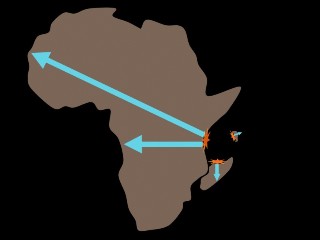
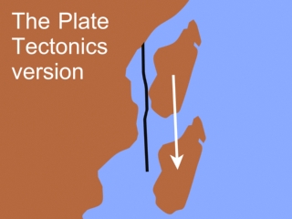
Plate Tectonics envisions Madagascar starting near Kenya. Madagascar, and the lithosphere it is sitting on, then drift south as a "microplate" with Davie Ridge as the west boundary of the microplate. However, many years ago it was determined that there is no evidence that Davie Ridge has ever been a transform fault (where plate sections slide past each other). Although the nodal [fault] planes are parallel to the ridge, "all the large to moderate-sized earthquakes have focal mechanisms of pure normal [pull-apart] faulting ...there is no significant component of strike-slip [slide by] motion." 5,2 p. 142 "This region is under east-west extension and seems to be within the same regional stress field as the East African rift system north of 5°S".5 p. 10,449 Nor has a continuous spreading rift developed north of Madagascar.2 Also, based on the geology alone, Madagascar moved to the east, and only a short distance.1 p. 694 Just looking at it in the starting position of the Plate Tectonics version, Madagascar seems a rather poor fit to the African coast.
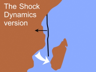
In Shock Dynamics, Madagascar began attached to Africa, and swung slightly to the east as Australia pulled away. Then westward tension on Africa from the separation of South and North America, the same tension that opened the East African Rift Zone, fractured the lithosphere at its weakest point at that moment - the impact site. This version fits the evidence better.
1. Boast, J., A.E.M. Nairn. 1982. An Outline of the Geology of Madagascar, Chapter 14 in The Ocean Basins and Margins, Volume 6: The Indian Ocean, editors A.E.M. Nairn and F. Stehli, Plenum Press, New York, pp. 649-696.
2. Chen, W.P., N.L. Grimison. 1989. Earthquakes associated with diffuse zones of deformation in the oceanic lithosphere: some examples. Tectonophysics, Vol. 166, pp. 133-150.
3. Coffin, M.F., P.D. Rabinowitz. 1988. Evolution of the conjugate East African-Madagascan margins and the western Somali Basin. Special Paper 226, The Geological Society of America, Boulder, pp. 1-78.
4. Coffin, M.F., P.D. Rabinowitz. 1987. Reconstruction of Madagascar and Africa; evidence from the Davie Fracture Zone and Western Somali Basin. Journal of Geophysical Research, Vol. 92:B9, pp. 9385-9406.
5. Grimison, Nina L., Wang-Ping Chen. September 10, 1988. Earthquakes in the Davie Ridge-Madagascar Region and the Southern Nubian-Somalian Plate Boundary. Journal of Geophysical Research, Vol. 93:B9, pp. 10,439-10,450.
6. Mougenot, D., M. Recq, P. Virlogeux, C. Lepvrier. 1986. Seaward extension of the East African Rift. Nature, Vol. 321, pp. 599-603.
7. Scrutton, R.A. 1978. Davie Fracture Zone and the movement of Madagascar. Earth and Planetary Science Letters, Vol. 39, pp. 84-88.
From
reference 6., page 21,202
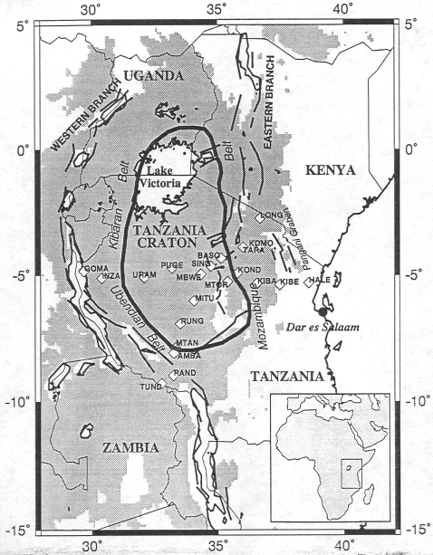
The Tanzania Craton
Current thinking on cratons is that they are the first parts of the continental lithosphere to have formed on Earth, and that they have survived over 2.5 billion years without much, if any, tectonic activity. They are thick, with a "keel" that extends to about 200 km depth, cold relative to other continental lithosphere, dehydrated, and "composed of highly melt-depleted peridotitic mantle" dominated by highly magnesian harzburgitic peridotite but depleted in clinopyroxene, calcium, iron, and aluminum compared to the asthenosphere and other peridotites.4 The main issues in the plate tectonics community regarding cratons concern their origin and survival relatively undisturbed for billions of years. The chemistry of cratons is complex, and seems to be "the residue of high-degree melting"2,3,4 at shallow depth and pressure, "and have since been transported to the great depths (90-200 km)" at which they are found now.4 In addition to melting, there also appears to have been metasomatic activity (interaction with fluids).3
The Tanzania Craton is in a very important location for the Shock Dynamics theory. It is right next to the impact crater, where the greatest stress in Africa would have occurred. The craton is on elevated terrain (shaded area above) that is part of the African Superswell, which covers the eastern and southern region of Africa.6 Average craton elevation is 1260 meters.7 It lies between the eastern and western branches of the East African Rift, a feature formed by the impact according to the theory. While the greenstone belts and granitoids that make up the crust of the craton have been assigned ages of over 2.5 billion years, with somewhat younger (Proterozoic) mobile belts (narrow folded belts formed by compression from collision) on the east and west sides7, all the features in this region appear to have been formed by the Shock Dynamics event. Thus the Tanzania Craton can provide a key to understanding the formation of the many other cratons that exist.
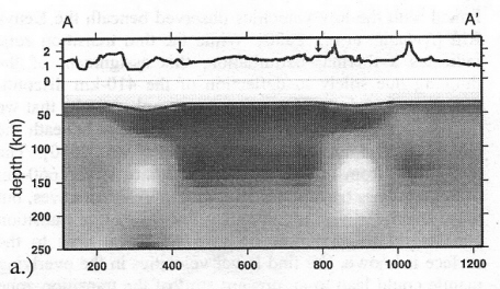
From
reference 7., page 10-14
This is an east-west seismic tomographic cross-section of the Tanzania Craton. The dark areas are denser than normal, while the light areas are less dense than normal and are considered to be composed of hot, partially molten material. The small arrows mark the boundaries of the craton. The wavy line below the arrows is the surface terrain. Though not apparent in the picture, the material below the craton at 200-250 km depth is so much less dense than normal that the researchers call it "unique", less dense than at "comparable depths beneath the East Pacific Rise spreading center" indicating "unusually high temperatures".7 Spreading ridges, like the East Pacific Rise, and rifts (pull-apart splits) at the surface can cause melting of deep rock material under high pressure by removing some of the pressure above it. The two branches of the East African Rift "are located mainly within the mobile belts"5 next to the craton. However, "the amount of extension across east Africa is very small (~10-15 km),6 so researchers propose that a mantle plume provided the heat.5,7 Unfortunately for their proposal, the existence of mantle plumes is doubtful (see home page of this website).
In the picture above, notice that the largest light spot is on the east side of the craton, nearest the impact crater. From the point of view of the Shock Dynamics theory, the African Superswell, the exceedingly hot material beneath the craton, and the large amount of partial melt on either side of the Tanzania Craton are a consequence of the giant meteorite impact. Severe stress on the lithosphere between the branches of the East African Rift from compression followed by extension caused high-temperature melting, and the residue foundered (sank). "Foundering of the mafic restites from granitoid magmas is very likely a major process" "for transporting material across the crust-mantle boundary".1 The origin of cratons by stress melting throughout the world is demonstrated on a special page.
1. Arndt, Nicholas T., Steven L. Goldstein. 1989. An open boundary between lower continental crust and mantle: its role in crust formation and crustal recycling. Tectonophysics, Vol. 161, pp. 201-212.
2. Arndt, Nicholas T., Eric Lewin, Francis Albarede. 2002. Strange partners: formation and survival of continental crust and lithospheric mantle. in The Early Earth: Physical, Chemical and Biological Development, Fowler, C.M.R., Ebinger, C.J., Hawkesworth, C.J., (eds). Geological Society, London, Special Publications, 199, pp. 91-103.
3. King, Scott D. 2005. Archean cratons and mantle dynamics. Earth and Planetary Science Letters, Vol. 234, pp. 1-14.
4. Lee, Cin-Ty Aeolus. 2006. Geochemical/Petrologic Constraints on the Origin of Cratonic Mantle. in Archean Geodynamics and Environments, Keith Benn, Jean-Claude Mareschal, Kent C. Condie, (eds). American Geophysical Union, Geophysical Monograph Series 164, pp. 89-114.
5. Owens, Thomas J., Andrew A. Nyblade, Harold Gurrola, Charles A. Langston. March 15, 2000. Mantle Transition Zone Structure Beneath Tanzania, East Africa. Geophysical Research Letters, Vol. 27, No. 6, pp. 827-830.
6. Ritsema, Jeroen, Andrew A. Nyblade, Thomas J. Owens, Charles A. Langston, John C. VanDecar. September 10, 1998. Upper mantle seismic velocity structure beneath Tanzania, east Africa: Implications for the stability of cratonic lithosphere. Journal of Geophysical Research, Vol. 103, No. B9, pp. 21,201-21,213.
7. Weeraratne, Dayanthie S., Donald W. Forsyth, Karen M. Fischer. 2003. Evidence for an upper mantle plume beneath the Tanzanian craton from Rayleigh wave tomography. Journal of Geophysical Research, Vol. 108, No. B9, 2427, ESE 10, pp. 1-17.
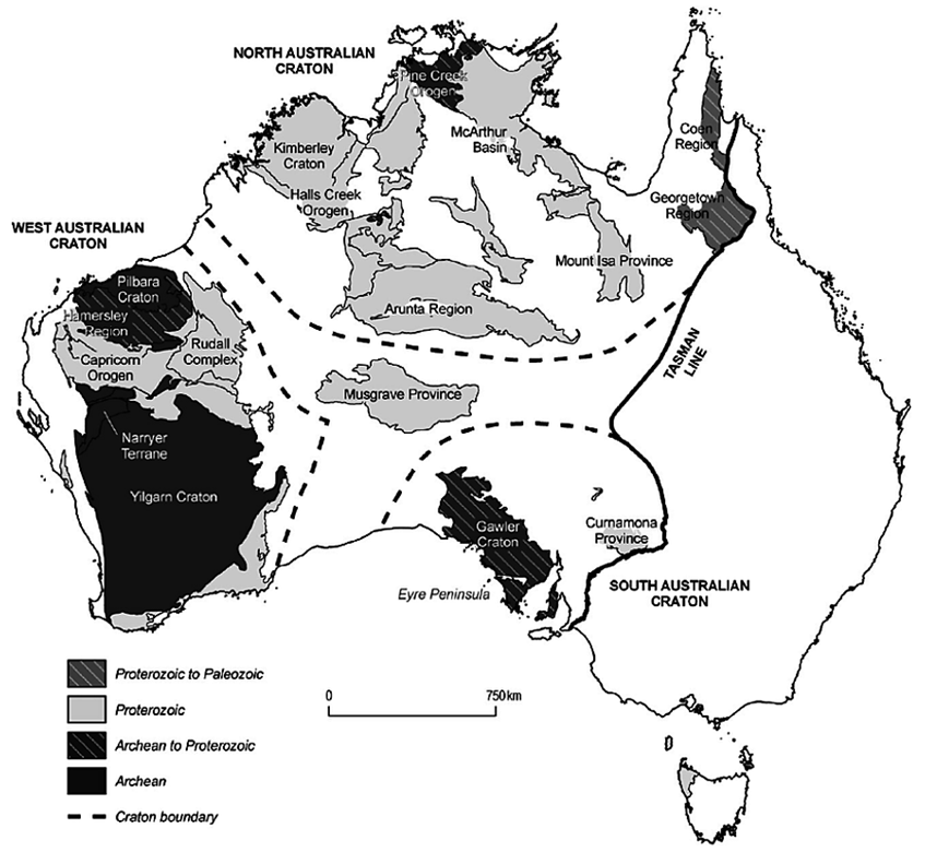
Notice in the map of Australian cratons below that the "Archean to Proterozoic" Gawler Craton is where the Great Australian Bight was crushed by the giant impact blast, as shown in the magnetic anomaly maps above. As with the Tanzania Craton, the Gawler Craton is clearly a consequence of the giant meteorite impact.
![]()